Save and Print Map
This tool allows you to save the current map extent (map view) in a multitude of image formats and sizes to be printed.
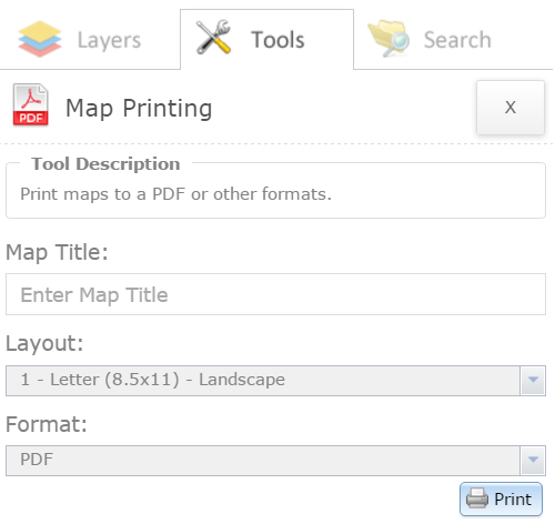
To use this tool:
- Enter the "Map Title" in the field provided. The map title value is required.
- Select the "Layout" drop down list and choose the type of template you wish to use for layout purposes.
The layouts available are as follows:
- Letter (8.5 X 11) - Landscape
- Letter (8.5 X 11) - Portrait
- Tabloid (11 X 17) - Landscape
- Tabloid (11 X 17) - Portrait
- A3 (11.7 X 16.5) - Landscape
- A3 (11.7 X 16.5) - Portrait
- A4 (8.3 X 11.7) - Landscape
- A4 (8.3 X 11.7) - Portrait
- Map Only
- Select the "Format" drop down list and choose the type of image format to output.
The formats available are as follows:
- GIF
- JPG
- PNG32
- PNG8
- Select the "Print" button. This will create the print for selection.
- Select the print shown in the available list. Once the print is selected, the map will appear in a new browser window.
- Save the file from the browser locally onto your computer. To do this, right click on the map and select Save as.
- To print the file, you may either print it directly from the browser or through the file saved on your computer.
- To clear the prints from the list, select the "Clear Prints" button.
- Select the Close button to close the tool.